 
| Subject: | |
| From: | |
| Reply To: | Maps, Air Photo & Geospatial Systems Forum |
| Date: | Tue, 4 Mar 2008 12:01:35 -0600 |
| Content-Type: | multipart/mixed |
| Parts/Attachments: |
|
|
-------- Original Message --------
Subject: Map symbology keys? 19th Century USCS charts?
Date: Tue, 04 Mar 2008 11:39:20 -0600
From: Maps-L Moderator <[log in to unmask]>
To: Maps-L <[log in to unmask]>
Erno,
There is a book entitled: Topographical drawings methodically arranged
and engraved for the use of officers of the army & navy, civil
engineers, academies, colleges and schools of science / by J. Enthoffer
... published by D. Appleton & Co. in 1869. There are 24 plates in
all. Hers are the contents note:
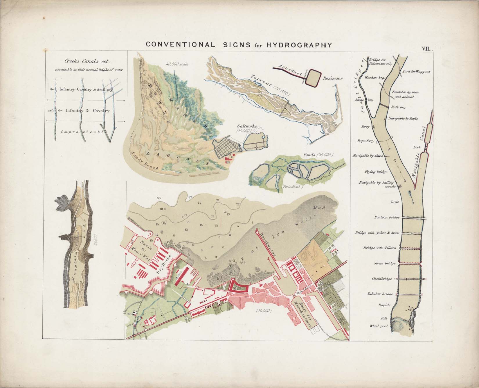
[Title page] Topographical drawings ... -- Plate I: Construction of
letters & figures -- Plate II: Alphabets and numerals -- Plate III: Map
lettering -- Plate IV: Conventional signs for the Army & Navy -- Plate
V: Conventional signs for topography [1] -- Plate VI: Conventional signs
for topography [2] -- Plate VII: Conventional signs for hydrography [1]
-- Plate VIII: Conventional signs for hydrography [2] -- Plate IX:
Conventional signs for fortreses, cities, etc. [1] -- Plate X:
Conventional signs for fortreses, cities, etc. [2] -- Plate XI:
Elementary rules of orographical design -- Plate XII: Types of orography
-- Plate XIII: Examples of hill shading [1] -- Plate XIV: Examples of
hill shading [2] -- Plate XV: Examples of hill shading [3] -- Plate XVI:
Glacier -- Plate XVII: Generalizing orographical details -- Plate XVIII:
Undulated country -- Plate XIX: Spurs of mountains -- Plate XX:
Mountains -- Plate XXI: Highland -- Plate XXII: Alps -- Plate XXIII:
High mountains -- Plate XXIV: Superglacial mountains.
Attached is an image of plate VII to give you an idea what it looks
like. It appears there are a number of libraries that hold this title
otherwise we have ours scanned. Feel free to contact us if you're
interested in obtaining copies. [log in to unmask]
Angie
Angie Cope, Senior Academic Librarian
American Geographical Society Library
UW Milwaukee Libraries
2311 E. Hartford Avenue
Milwaukee, Wisconsin 53201
http://www.uwm.edu/Libraries/AGSL/index.html
Hours: M-F 8:00am-4:30pm
[log in to unmask]
(414)229-6282 / (800)558-8993 (US TOLL FREE) / (414)229-3624 (FAX)
43°03'8"N 87°57'21"W
-------- Original Message --------
Subject: Map symbology keys? 19th Century USCS charts?
Date: Tue, 4 Mar 2008 12:29:22 -0500
From: erno bonebakker <[log in to unmask]>
To: [log in to unmask]
The Marsh & Mclellan inquiry prompts me to ask the larger question-
can anyone suggest finding aids for map symbology keys in general?
I am currently looking for a key to land based cultural features (such
as roads, land cover) on a US Coast Survey chart of Casco Bay Maine
(#315) circa 1870 or later.
no luck so far through Google
Erno R Bonebakker, mapster
91 Park St.
Portland, ME 04101
207.874.6664
note new address: [log in to unmask]
|
|
|


