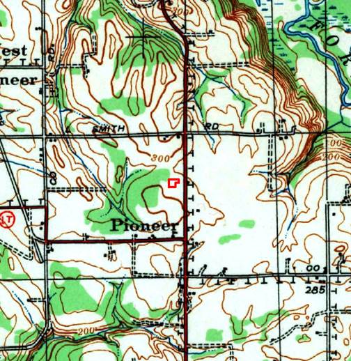
There is a whole book of USGS topographic symbols (from 1961) available:
https://hdl.handle.net/2027/uiug.30112070112047

I see "Tel" for telegraph or telephone lines
<https://hdl.handle.net/2027/uiug.30112070112047?urlappend=%3Bseq=80>.
There's a "T" listed for telegraph office
<https://hdl.handle.net/2027/uiug.30112070112047?urlappend=%3Bseq=98>, but
that wouldn't make sense in a line like that.

On Mon, Jan 20, 2020 at 10:04 PM David Hodnefield <[log in to unmask]>
wrote:

> Howdy folks.
>
>
>
> I have a client who is trying to figure out what the symbol “T” means on a
> USGS topographic map (see below).  The map is from 1940 and I don’t see any
> interpretation of it on the USGS key of symbols (
> https://pubs.usgs.gov/gip/TopographicMapSymbols/topomapsymbols.pdf).  My
> suspicion is a transmission or telephone line, but that’s only a guess.
> Thanks for your help.
>
> [image: cid:image001.jpg@01D5CFBA.0C471770]
>
>
>
>
>
> [image: cid:image002.jpg@01D2F71A.D4FBAE40]
> <http://www.historicalinfo.com/fimo/>   [image: seemoreincolor]
>
>
>
> *David Hodnefield*
>
> *President*
>
> [log in to unmask]
>
> 952-253-2004 ext 111
>
>
>
> *Historical Information Gatherers (HIG)*
>
> www.historicalinfo.com/fimo/
>
> [image: LinkedIn-Logo-02] <https://www.linkedin.com/organization/2985404>[image:
> facebook icon]
> <https://www.facebook.com/search/top/?q=historical%20information%20gatherers%20-%20hig>[image:
> twitter icon] <https://twitter.com/HistoricalInfo1>[image: youtube icon]
> <https://www.youtube.com/playlist?list=PLftxFDJe-tuucvIyAujnPQa7mKcddUAED>
>
>
>
>
>
>
>


--
Ryan Mattke
Map & Geospatial Information Librarian

Head, John R. Borchert Map Library <https://www.lib.umn.edu/borchert>
Adjunct Faculty, MGIS Program <http://cla.umn.edu/mgis>
Project Lead, Big Ten Academic Alliance Geospatial Data Project
<https://sites.google.com/umn.edu/btaa-gdp/>
Co-Director, Mapping Prejudice Project <https://www.mappingprejudice.org/>

Phone: 612.624.5757
Web: http://www.lib.umn.edu/borchert <https://www.lib.umn.edu/borchert>
ORCID: http://orcid.org/0000-0001-8816-9289
--
--
Ryan Mattke
Map & Geospatial Information Librarian

Head, John R. Borchert Map Library
Adjunct Faculty, MGIS Program

Phone: 612.624.5757
Web: http://www.lib.umn.edu/borchert
ORCID: http://orcid.org/0000-0001-8816-9289


