 
| Subject: | |
| From: | |
| Reply To: | Maps-L: Map Librarians, etc. |
| Date: | Tue, 21 Jan 2020 10:30:55 -0500 |
| Content-Type: | multipart/related |
| Parts/Attachments: |
|
|
I agree with Ryan's assessment ("T" for telegraph office makes no sense as
a linear feature), but the book he pointed to is a US Army Field Manual,
not a USGS pub. And I'm not sure how much of the symbology would apply to
USGS topos?
But! See Plate 19 of "Topographic instructions of the United States
Geological Survey : Topographic mapping" [1928] at
https://pubs.usgs.gov/bul/0788e/report.pdf
Telegraph or telephone line it is!
mf
On Tue, Jan 21, 2020 at 8:53 AM Ryan Mattke <[log in to unmask]> wrote:
> There is a whole book of USGS topographic symbols (from 1961) available:
> https://hdl.handle.net/2027/uiug.30112070112047
>
> I see "Tel" for telegraph or telephone lines
> <https://hdl.handle.net/2027/uiug.30112070112047?urlappend=%3Bseq=80>.
> There's a "T" listed for telegraph office
> <https://hdl.handle.net/2027/uiug.30112070112047?urlappend=%3Bseq=98>,
> but that wouldn't make sense in a line like that.
>
> On Mon, Jan 20, 2020 at 10:04 PM David Hodnefield <
> [log in to unmask]> wrote:
>
>> Howdy folks.
>>
>>
>>
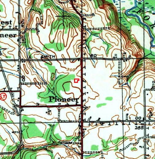
>> I have a client who is trying to figure out what the symbol “T” means on
>> a USGS topographic map (see below). The map is from 1940 and I don’t see
>> any interpretation of it on the USGS key of symbols (
>> https://pubs.usgs.gov/gip/TopographicMapSymbols/topomapsymbols.pdf). My
>> suspicion is a transmission or telephone line, but that’s only a guess.
>> Thanks for your help.
>>
>> [image: cid:image001.jpg@01D5CFBA.0C471770]
>>
>>
>>
>>
>>
>> [image: cid:image002.jpg@01D2F71A.D4FBAE40]
>> <http://www.historicalinfo.com/fimo/> [image: seemoreincolor]
>>
>>
>>
>> *David Hodnefield*
>>
>> *President*
>>
>> [log in to unmask]
>>
>> 952-253-2004 ext 111
>>
>>
>>
>> *Historical Information Gatherers (HIG)*
>>
>> www.historicalinfo.com/fimo/
>>
>> [image: LinkedIn-Logo-02] <https://www.linkedin.com/organization/2985404>[image:
>> facebook icon]
>> <https://www.facebook.com/search/top/?q=historical%20information%20gatherers%20-%20hig>[image:
>> twitter icon] <https://twitter.com/HistoricalInfo1>[image: youtube icon]
>> <https://www.youtube.com/playlist?list=PLftxFDJe-tuucvIyAujnPQa7mKcddUAED>
>>
>>
>>
>>
>>
>>
>>
>
>
> --
> Ryan Mattke
> Map & Geospatial Information Librarian
>
> Head, John R. Borchert Map Library <https://www.lib.umn.edu/borchert>
> Adjunct Faculty, MGIS Program <http://cla.umn.edu/mgis>
> Project Lead, Big Ten Academic Alliance Geospatial Data Project
> <https://sites.google.com/umn.edu/btaa-gdp/>
> Co-Director, Mapping Prejudice Project <https://www.mappingprejudice.org/>
>
> Phone: 612.624.5757
> Web: http://www.lib.umn.edu/borchert <https://www.lib.umn.edu/borchert>
> ORCID: http://orcid.org/0000-0001-8816-9289
> --
> --
> Ryan Mattke
> Map & Geospatial Information Librarian
>
> Head, John R. Borchert Map Library
> Adjunct Faculty, MGIS Program
>
> Phone: 612.624.5757
> Web: http://www.lib.umn.edu/borchert
> ORCID: http://orcid.org/0000-0001-8816-9289
>
--
Michael Fry
Collections Manager | Map Library Manager
National Geographic Society Library
202.807.3139
[log in to unmask]
[image: Nat Geo Logo Yellow_Black.png] <http://www.nationalgeographic.org>
1145 17th St., NW, Washington, DC 20036
[image: Email-Signature8.gif] <https://donate.nationalgeographic.org/em-sig>
|
|
|


