MAPS-L Archives

Maps-L: Map Librarians, etc.

MAPS-L@LISTSERV.UGA.EDU

Options: Use Forum View

Use Monospaced Font
Show HTML Part by Default
Show All Mail Headers

Message: [<< First] [< Prev] [Next >] [Last >>]
Topic: [<< First] [< Prev] [Next >] [Last >>]
Author: [<< First] [< Prev] [Next >] [Last >>]

Print Reply
Subject:
From:
"Diaz, Tony A." <[log in to unmask]>
Reply To:
Maps-L: Map Librarians, etc.
Date:
Fri, 5 May 2023 14:18:05 +0000
Content-Type:
multipart/mixed
Parts/Attachments:
text/plain (408 bytes) , text/html (2740 bytes) , Spreading_homo_sapiens_la.svg.png (69 kB) , OutofAfrica_Migration.jpg (239 kB)
Hello all,

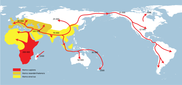
I'm trying to find an OpenStreetMap, that shows the Pacific at the center of the map.
The idea is to overlay the Ring of Fire, and then show the Out-of-Africa migration.

Can something like this be done in QGIS or similar?


Tony Diaz | Geology & Planetary Sciences Librarian | Caltech Library
Mail Code 100-23 | Pasadena CA 91125 | 626-395-6699 | www.library.caltech.edu<http://www.library.caltech.edu/>


ATOM RSS1 RSS2